Joshimath Sinking: Town Sank 5.4 cm in 12 Days, Show Satellite Images As Concerns Mount Amid Demolitions
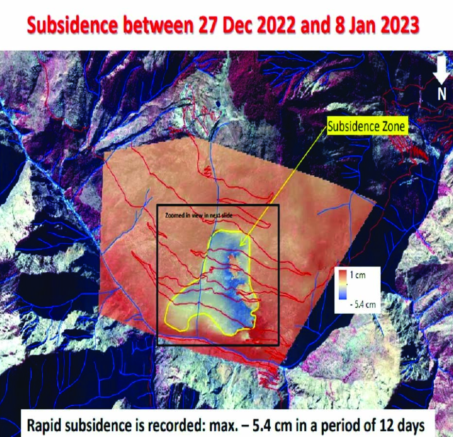
(News Agency) Joshimath town in Uttarakhand sank at a rapid pace of 5.4 cm in just 12 days due to triggering by a possible subsidence event on January 2, satellite images released by the Indian Space Research Organisation (ISRO) revealed. A study by ISRO’s National Remote Sensing Centre (NRSC) said the land subsidence in Joshimath was slow between April and November 2022 during which the town sank by up to 8.9 centimetres. However, between December 27, 2022, and January 8, 2023, the intensity of land subsidence increased and the town sank by 5.4 cm in these 12 days, the preliminary study stated. Pictures taken from the Cartosat-2S satellite revealed the rapid surface displacement was taking place within a span of a few days and the areal extent of subsidence has also increased. But it is confined to the central part of Joshimath town, it noted.The subsidence zone resembling a generic landslide shape tapered top and fanning out at base was located with its crown near Joshimath-Auli road at a height of 2,180 metres. Prominent landmarks in the subsidence zone were Army Helipad and Narsingh Temple.
JOSHIMATH LAND SUBSIDENCE PREDICTED IN 2021
Meanwhile, the Indian Institute of Technology (IIT) Ropar said that its researchers had predicted large-scale subsidence in Joshimath in 2021.
The study predicted between 7.5 and 10 centimetres (cm) displacement for buildings in Joshimath, enough to cause large-scale cracks in buildings. Remote sensing data using the Persistent Scatterer Synthetic Aperture Radar (PSInSAR) Interferometry technique was used to examine the sinking.
Explaining the process, Reet Kamal Tiwari, Assistant Professor, Department of Civil and Environmental Engineering, IIT-Ropar said, “a signal from an SAR satellite interacts with different targets and goes back to the sensor located in the satellite, based on which an image is created. In our study, Sentinel 1 SAR satellite data was used."
Built-up structures such as buildings act as persistent or permanent scatterers for active SAR sensors. Scatterers refers to a change in the direction of light because of its collision or interaction with another particle, including buildings. Changes in the images taken over a period of time help in accurate identification. “Since persistent scatterers are not usually expected to move, therefore, any movement, even on a scale of millimetres, arising from crustal deformations or seismic activity or even structural failure is captured precisely," Tiwari said.Researchers had initially investigated the surface displacement of Tapovan, a tourist spot near Joshimath, as a result of the flash floods of February 2021 in Chamoli. It was observed Joshimath was recording a surface displacement of up to 8.5 centimetres which was on an upward trend. Joshimath, being only 15 kilometres away from Tapovan, was captured in the satellite images, enabling the scientists to go back in time up to January 2020 and look at all the data, this time to study the surface displacement of the town.Remote sensing data along with artificial intelligence (AI) algorithms were then used to predict the land subsidence in Joshimath. The study in which 16 images received using the PSInSAR technique from January 2020 to April 2021 were ran through a machine learning model. The result predicted the displacement to go up to 8.5-10 centimetres in the near future, making the land subsidence enough to for cracks to develop in buildings.“Currently, the displacement figures may even be more and could be analysed in greater detail because every 12 days, more data is being added with successive satellite passes and ground displacement happening steadily," said Tiwari.
25 FAMILIES EVACUATED, TALLY RISES TO 185
Twenty-five more families were evacuated from subsidence-hit houses, taking the total number of families affected by the land subsidence in the town to 185, according to the District Disaster Management Authority, Chamoli. The number of houses that have developed cracks stands at 760, out of which 147 have been marked unsafe, it said.Chief Minister Pushkar Singh Dhami said the government’s biggest priority is to provide quick relief to the affected people and evacuate them to safety. He chaired a cabinet meeting during which a slew of decisions, including a six-month waiver of water and electricity bills and a one-year moratorium on recovery of bank loans, were taken for to the affected people. It also decided to conduct a study on the carrying capacity of all towns located in the hills. It also decided to increase from Rs 4,000 to Rs 5,000 per month the amount being given by the state government to the affected families for payment of rent. In a relief, each affected family staying in temporary relief camps built in hotels and residential units will be paid Rs 950 per room per day for their accommodation besides Rs 450 per head per day for expenses. Besides, they will get Rs 80 per day to buy feed for big animals and Rs 45 for small ones.Interim assistance of Rs 1.5 lakh has been distributed to 42 affected families so far, Chamoli District Magistrate Himanshu Khurana said.